


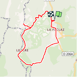
La Feclaz -Le Sire

Bogapuki
User

Length
8.6 km

Max alt
1528 m

Uphill gradient
376 m
Km-Effort
13.6 km

Min alt
1292 m

Downhill gradient
376 m
Boucle
Yes
Creation date :
2018-11-25 09:19:15.417
Updated on :
2018-11-25 09:19:15.417
2h41
Difficulty : Easy

FREE GPS app for hiking
 SityTrail
IGN / Geographical institutes
SityTrail Plus
The world is yours!
About
Trail Walking of 8.6 km to be discovered at Auvergne-Rhône-Alpes, Savoy, Les Déserts. This trail is proposed by Bogapuki.
Photos


Positioning
Country:
France
Region :
Auvergne-Rhône-Alpes
Department/Province :
Savoy
Municipality :
Les Déserts
Location:
Unknown
Start:(Dec)
Start:(UTM)
732393 ; 5059296 (31T) N.
Comments